Introduction
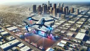
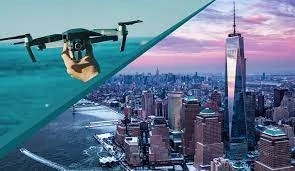
In today's digital age, aerial photography has revolutionized industries like agriculture and real estate. Real estate drone photography has become an essential tool for showcasing properties with stunning perspectives, capturing potential buyers' attention, and increasing sales. Similarly, agricultural drone photography provides farmers and landowners with crucial insights into crop health, irrigation management, and land planning. At Petrossian Aerial, we specialize in Los Angeles agriculture and real estate drone photography, delivering high-quality aerial imagery tailored to your specific needs.
The Importance of Drone Photography in Real Estate
Enhancing Property Listings with Aerial Shots
In real estate, first impressions matter. Traditional photography limits the buyer's perspective, often failing to showcase the true potential of a property. Aerial drone photography allows realtors to present:
- Expansive Property Views: Aerial shots provide a comprehensive view of the entire property, including landscape, neighborhood, and amenities.
- High-Resolution Imagery: Crisp, clear images showcase every detail, making listings more attractive to buyers.
- Engaging Virtual Tours: Combining drone footage with virtual walkthroughs offers an immersive experience, helping buyers envision themselves in the home before visiting in person.
Increasing Marketability and Faster Sales
Properties with drone-captured images and videos tend to sell faster and at higher prices. According to real estate studies, listings featuring drone photography receive higher engagement and more inquiries than those with standard images. Potential buyers appreciate the ability to see a property from above, offering a better understanding of:
- Lot boundaries
- Proximity to key landmarks
- Landscaping and outdoor features
By using real estate drone photography, Petrossian Aerial helps realtors create compelling property listings that stand out in a competitive market.
The Role of Drone Photography in Agriculture
Precision Farming with Drone Imagery
In agriculture, technology is playing an increasingly vital role in improving productivity and efficiency. Agricultural drone photography provides farmers with real-time data on crop health, irrigation, and soil conditions. Drones equipped with specialized sensors can capture:
- Multispectral and Thermal Imaging: Identifies areas of stress, disease, or nutrient deficiency in crops.
- Soil and Irrigation Analysis: Helps monitor moisture levels and optimize irrigation schedules.
- Pest and Disease Detection: Early identification of infestations or disease outbreaks, reducing the need for excessive pesticide use.
Cost-Effective and Time-Saving Solutions
Traditionally, farmers relied on manual field inspections, which are time-consuming and prone to human error. Drone photography eliminates this issue by offering quick, accurate, and efficient data collection over large areas. By investing in agriculture drone photography, farmers can:
- Reduce operational costs
- Optimize resource allocation
- Increase overall yield and profitability
Advantages of Drone Photography for Agriculture and Real Estate
High-Quality Aerial Imagery
Petrossian Aerial employs state-of-the-art drone technology to capture stunning high-resolution images and videos. Whether you need sweeping landscape shots for a real estate listing or precise crop analysis, our drones deliver top-tier results.
Advanced Data Analytics
For agriculture clients, we go beyond photography by integrating data analysis tools. Our drones collect multispectral data that allows farmers to make informed decisions about their crops, leading to improved efficiency and higher yields.
Cost Savings and Efficiency
Compared to traditional aerial photography using helicopters or planes, drones are significantly more cost-effective. Our services provide superior quality imagery at a fraction of the cost, making drone photography an affordable and scalable solution for both industries.
Applications of Drone Photography in Los Angeles
Real Estate Marketing
Los Angeles is home to a diverse real estate market, from luxury beachfront properties to expansive rural estates. Drone photography is a game-changer for realtors looking to attract high-end buyers by offering:
- Aerial views of properties
- 360-degree virtual tours
- Detailed site analysis
Agricultural Land Monitoring
California’s agricultural industry is a crucial part of its economy. Farmers in Los Angeles and surrounding areas utilize drone imagery for crop health monitoring, land surveying, and yield forecasting. Our aerial photography services help farmers implement precision agriculture techniques for sustainable farming practices.
Construction Site Mapping
Drones are also invaluable for construction projects, providing progress tracking, topographical surveys, and safety assessments. Our aerial construction site photography ensures project managers stay informed about site conditions in real time.
Why Choose Petrossian Aerial?
At Petrossian Aerial, we specialize in professional drone photography for agriculture, real estate, and commercial industries. Here’s why our clients trust us:
- Experienced Pilots: Our FAA-certified drone pilots ensure safe and legal aerial operations.
- Cutting-Edge Technology: We use the latest drone equipment with high-resolution cameras and advanced imaging sensors.
- Customized Solutions: Whether you need real estate marketing videos or agriculture monitoring, we tailor our services to meet your requirements.
- Fast Turnaround: Our team ensures quick project completion without compromising on quality.
Conclusion
Drone photography is transforming both the real estate and agricultural sectors in Los Angeles. By leveraging real estate drone photography, realtors can create visually appealing listings that captivate buyers, while farmers can enhance crop management with agricultural drone imagery. At Petrossian Aerial, we are committed to providing top-notch Los Angeles drone photography services, ensuring our clients achieve their goals with stunning aerial visuals and precise data insights. Contact us today to elevate your real estate listings or optimize your agricultural operations with the power of drone technology!


Sign in to leave a comment.